Altitude 2261 m/s.l.m.
Municipality Ragoli
Mountain group
Dolomiti
Location
Dolomiti di Brenta - Grostè
History and environment
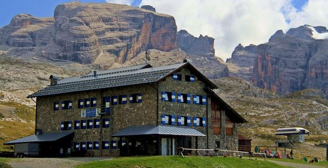
The Gràffer hut was built in 1947 by a cooperative of members; in 1956 the cooperative sold it for a symbolic sum to the S.A.T. The refuge is today at the center of an area equipped for skiing while in the summer it is the ideal starting point for the Via delle Bocchette and for the wild and peaceful northern Brenta. The refuge is named after one of the most talented climbers in the history of Dolomite mountaineering, Giorgio Gràffer. Even today, Giorgio Gràffer’s routes are selective. He was born in Trento in 1912 and, in just a few years, left an indelible mark over the history of mountaineering. He died in 1940 falling with his plane in the skies of Albania. The refuge was recently renovated by the S.A.T. and inaugurated in the summer of 1990, it is the cultural-mountaineering reference point for the S.A.T. and the C.A.I. as a multipurpose structure, designed to also host refresher courses.
Guides and maps
Mountaineering guide: BUSCAINI, Gino – CASTIGLIONI, Ettore, Brenta Dolomites, Milan, CAI, TCI, 1977 (Italian Mountain Guide) Hiking guide: GARDUMI, Enzo – TORCHIO, Fabrizio, Guide to the Brenta Dolomites, Trento, Panorama, 1987-1990, 3 volumes. Cartography: – Brentagruppe = Gruppo di Brenta, 4. ed., München, Deutschen Alpenverein, 1996, Scale 1:25.000 (Alpenvereinskarte; 51) – KOMPASS map in scale 1:25.000 n. 688 “Brenta group”.
Access
- From Campo Carlo Magno Pass m. 1681 along the forest road that passes through the Prati di Pozza Vecchia m. 1750 and from Pozza di Boc m. 1895 – 2 hours.
- from Passo del Grostè m. 2442 (cableway from Campo Carlo Magno), by road, in 20 minutes (trail sign 301) – from the Vallesinella di Sopra restaurant m. 1681, path 382 up to Fontanafredda m. 2162, then with path 331 – 2.15 hours.

Follow us on our social channels and use the hashtag #guidealpinevaldisole