Altitude 2298 m/s.l.m.
Municipality Vermiglio
Mountain group
Adamello Presanella
Location
Circo di Stavèl
History and environment
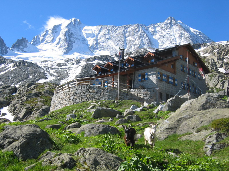
The hut was built in 1898 and inaugurated on the 21st of August 1899, becoming the basecamp for mountaineers who wanted to climb the daring Presanella, along its northern slope. It is located at an altitude of 2298 m. on a terrace just below a small lake and at the base of the moraine of the Presanella glacier. The brevity of the access route (from the forts only an hour and a half) makes it the destination of many excursions; its location is such as to range from the top of Presanella, to Cima Vermìglio up to Vioz and Cevedale, as well as naturally dominating the Val Stavèl. Denza is the ideal base for one of the classic ice ascents of the Alps, the north face of the Presanella, which rises behind the refuge in all its beauty. Among the extreme ice routes on the vertical north face we can’t forget to highlight the hanging glacier and the Cima Vermìglio. The hut has undergone a series of renovations, the last of which dates back to 2000. Today it is a functional and comfortable refuge, equipped with a large winter bivouac. It is named after Father Francesco Denza, Barnabite, astronomer and famous meteorologist, director of the Vatican Observatory between 1890 and 1894, who was close to the S.A.T. when the construction of a network of meteorological stations was undertaken.
Guides and maps
Mountaineering guide: ONGARI, Dante, Presanella, Milan, CAI, TCI, 1978 (Italian Mountain Guide) Hiking guide: COMENSOLI, Diego – MOCHEN, Tiziano – TURETTI, Paolo, Presanella hiking guide, Calliano (TN), Manfrini, 1993 Cartography: – KOMPASS map in scale 1:25.000 n. 639 “Presanella”.
Access
Continuing by car after the town of Vermiglio, in the direction of Velon, you reach the crossroads with the recently renovated dirt road that leads to the former Forte Pozzi Alti (1884 m). The road, about 6.2 km long, is accessible to all without the need for any permit. Those who want to walk this stretch too can avoid following the road completely, being able to take the SAT path 233 which, cutting through the hairpin bends, leads to the former Forte Pozzi Alti in about 1.30 hours. From the high-altitude “car park” you can reach the hut in about 1.15 hours thanks to the comfortable and fascinating SAT path 233. The latter develops only for 400 meters in altitude and it is very suggestive, it is in fact a former Austrian mule track from the First World War that crosses a tunnel passing under a small waterfall.
Another possibility is to start from Stavèl, taking the SAT path 206 which then reconnects with the SAT 233 path. The journey time is approximately 3.30 hours.
From Passo del Tonale
Those who wish to start from Passo del Tonale, on the other hand, can reach us by following the so-called Sentiero degli Alpini, a former military itinerary (s. SAT n°218) which starts shortly after taking the road that leads to the Alveo Presena. After about 2 hours you will arrive at Forte Pozzi Alti and from here the usual SAT path no°233 will take you to the hut. An alternative to the SAT path 233 from Forte Pozzi to the refuge (or vice versa) is offered by the SAT path 234 which ends beyond the Passo dei Pozzi (2604 m) and with a clear sky the view can range from the Bernina to the Ortles Cevedale group, Adamello and Brenta.

Follow us on our social channels and use the hashtag #guidealpinevaldisole