Altitude 2272 m/s.l.m.
Municipality Ragoli
Mountain group
Dolomiti
Location
Dolomiti di Brenta - Vedretta di Brenta inferiore
History and environment
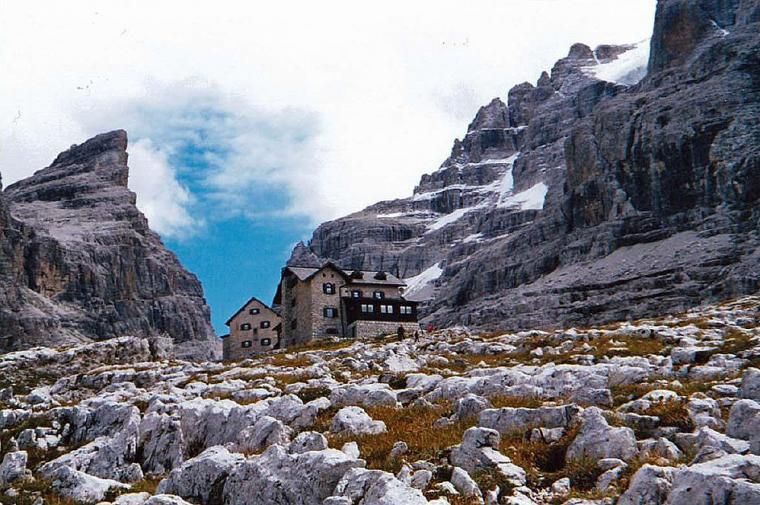
Located one next to the other, in the Upper Vallesinella, central-western section of the Brenta Dolomites, the Tuckett and Sella refuges are an example of the opposition that at the beginning of the century characterized the relations between “Italian” Trentino mountaineers and Germans. The Sella, which is the most upstream and of modest dimensions, was built by the Italians in the years 1904-’05 and dedicated to the founder of the Italian Alpine Club, Quintino Sella. Already the following year, in 1906, at the inauguration of the Q. Sella, the climbers of the Sektion Berlin of the D.u.Oe.A.V. provided for the construction, less than twenty meters away, of a new building, which they called Tuckett passhütte in honor of the British mountaineer Francis Fox Tuckett. Looted during the Great War, they were restored in 1920 by the S.A.T., after the latter had also bought the German hut. Today the Sella refuge has become functional at the Tuckett. Their relatively low altitude (2272 m.), their accessibility and proximity to Madonna di Campiglio make them one of the main destinations in the Brenta Dolomites. From here you can leave for excursions in the entire central chain of the group and for ascents to Cima Brenta or to Castelletto Inferiore, the peak that dominates the two buildings. Through the Via delle Bocchette, it is possible to go both towards the Tosa refuges, passing between the Sfúlmini spiers, and to go north to reach the Grostè Pass and the Gràffer refuge. The panorama towards the west is also vast, on the white expanses of perennial ice that go from Carè Alto (South) to Presanella (North).
Guides and maps
Mountaineering guide: BUSCAINI, Gino – CASTIGLIONI, Ettore, Brenta Dolomites, Milan, CAI, TCI, 1977 (Italian Mountain Guide) Hiking guide: GARDUMI, Enzo, TORCHIO, Fabrizio, Guide to the Brenta Dolomites, Trento, Panorama, 1987-1990, 3 volumes. Cartography: – Brentagruppe = Gruppo di Brenta, 4. ed., München, Deutschen Alpenverein, 1996, Scale 1:25.000 (Alpenvereinskarte; 51) – KOMPASS map in scale 1:25.000 n. 688 “Brenta group”.
Access
- from Malga Vallesinella di Sotto m. 1513 (4 km from Madonna di Campiglio), path 317 (or 382 and 317/bis which passes through Vallesinella di Sopra m. 1681) to Casinei refuge m. 1825 – 1.45/2 hrs.
- from Passo del Grostè m. 2442 (cableway from Campo Carlo Magno) along path 316 – 1.20 hrs.

Follow us on our social channels and use the hashtag #guidealpinevaldisole